CanWest Global Park
Downtown on the river, near the Forks and Portage & Main
Directions from the south (heading downtown)
- Follow the Pembina Highway all the way downtown
(over the Assiniboine River)
- Follow signs for The Forks along Main Street
- Head East on Water St. towards Provencher Bridge
- Pass under railroad trestle
- Parking is on left (though in the "dangerous" foul ball territory) or on right
Directions from the west (on Portage)
- Follow Portage Ave all the way downtown to Main Street
- Take slight right onto Portage Ave. East
(in front of Fairmont Hotel)
- One block to parking or right (south) at traffic light
- South to second light at Water St.
- Pass under railroad trestle
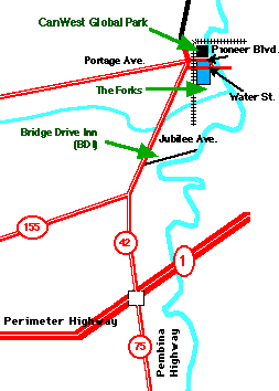
Where is it on the map?
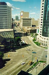
Portage & Main (1999)
The Heart of Downtown Winnipeg
...only 3 blocks from CanWest Global Park
It was new in '99, so it probably won't be on older maps (especially if it doesn't show the changes to the streets around the ballpark during 2003).
What you can find is the railroad crossing the river north of one of the few bridges over the Red River. You can also find the Provencher Bridge which crosses just upstream (south) of the train. The ballpark is between these north of the street and just south of the track.
A detailed downtown map will indicate Pioneer and Water Avenues. These are essentially extensions of Notre Dame Ave. (another major downtown street) if it didn't end at Portage.
It's also just a few blocks from the "heart" of downtown at Portage and Main. This you'll find in nearly any map of Winnipeg, and in any detailed downtown versions.
All of this will change in 2002 when the Provencher Bridge is closed and replaced. There are plans to reroute Pioneer Ave. away from the ballpark (allowing it to expand along the first base line) and may include a new train bridge instead of the current narrow "tunnels" under the rails.
What landmarks should I look for?
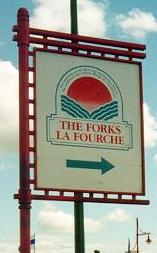
Sign for The Forks / La Fourche
Look for "The Forks/La Fourche" and signs leading to it like the one shown here. The park isn't really part of the The Forks complex, but it is "just downstream." Both are on a river plain originally used as a massive railroad switchyard. To get there (from the west) you have to go under the large train trestle separating down town from the river.
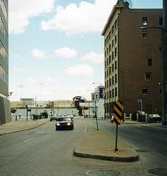
Ballpark View from Portage & Main (down Portage)
Just visible behind the railroad trestle
The Forks are at the "forks" (meeting of the Assiniboine and Red Rivers), the park is due north. The park is right up next to the train trestle before it crosses the river.
Special consideration should be made for the one way streets heading to and from downtown. Pioneer Boulevard runs just south of the park and is one way headed east (downtown). Water Street is a "half block" south of Pioneer and one way headed east towards the bridge and St. Boniface. There's a parking lot is between but be warned: This is a "danger zone" since it's prime territory for foul balls, though much less so thanks to the new routes past the ballpark.
City streets around the ballpark lead to additional lots north and west of the ballpark. A new street along the Red River, Riverside Drive, is just beyond the outfield and leads to other streets and parking.
What you should bring with you?
At the northern extreme of the Northern League, the start and end of the season may be time for a jacket or sweatshirt. But as one of the prairie ballparks, it is possible to attend night games without them.
Since most of the grandstand faces south, sunscreen is likely to be a necessity for day games. Like it's smaller twin (in Fargo) to the south, there should be enough shelter from rainstorms.